Designing a rural postal route in Canada starts with a question that does not appear in urban planning: how many kilometres of driving does each delivery point justify? In a city, one carrier might handle 600 addresses within a two-kilometre radius. In central Saskatchewan, the same carrier might cover 140 kilometres to reach 230 addresses — and some of those addresses will only appear on the route map because a farmhouse was built at the end of a six-kilometre private lane.
Canada Post publishes national delivery standards but leaves route geometry largely to regional planners who work with provincial road data, seasonal access records, and census address files. The result is a patchwork of routes that share the same postal code prefix but vary enormously in structure.
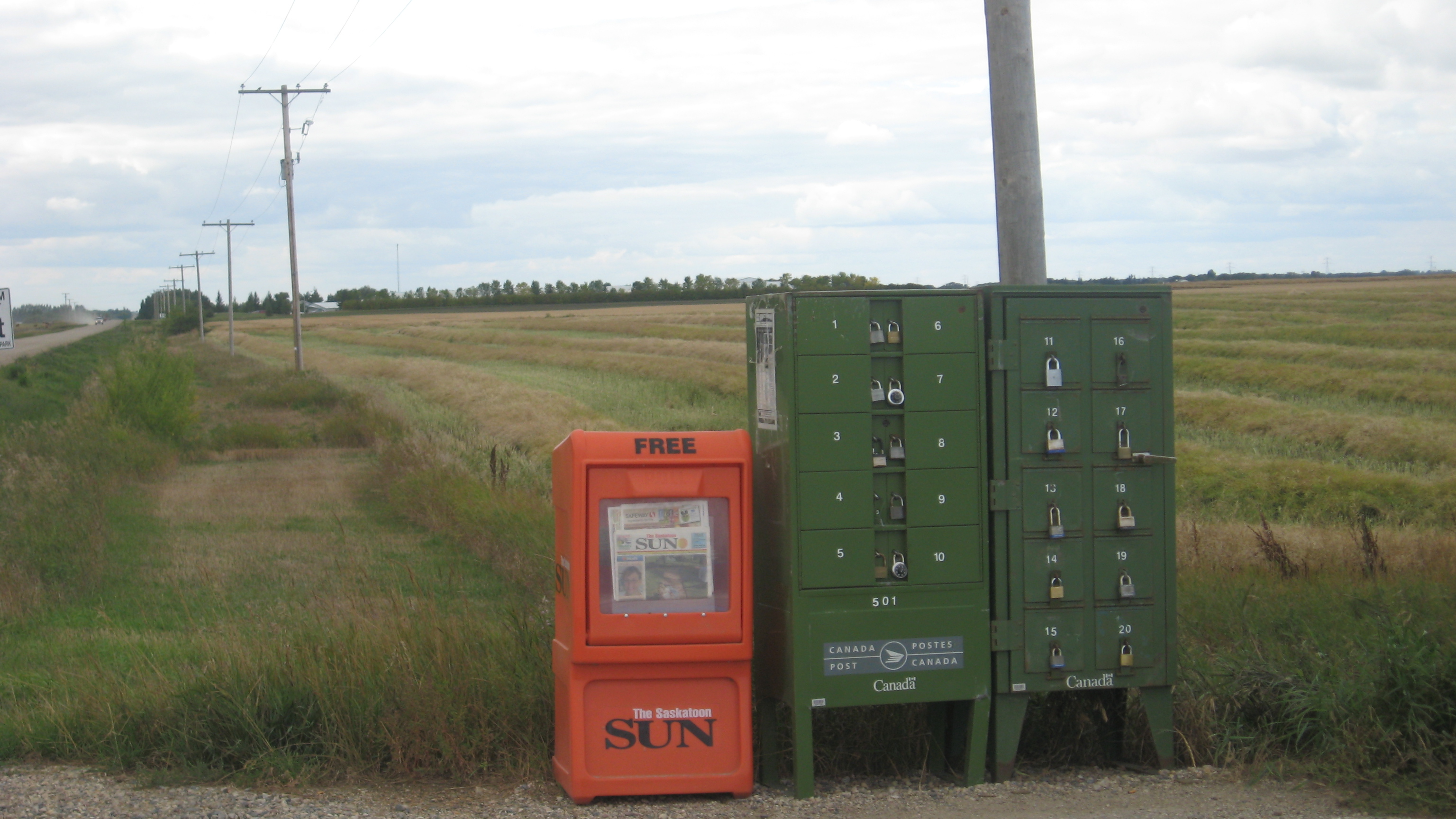
How Rural Routes Are Structured
Rural routes in Canada fall into two broad categories: franchise routes, operated by contracted individual carriers who use their own vehicles, and community mailbox (CMU) routes, where Canada Post installs a cluster of mailboxes at a fixed point and customers collect their own mail.
Franchise carriers are typically paid a flat daily rate per route rather than per item, which means route design directly affects carrier income per hour worked. A route that is geographically efficient — densely clustered delivery points accessible from a main road — can be completed faster than its nominal load suggests. A sprawling route with many dead-end lanes may require hours of driving for a volume that looks manageable on paper.
Route assignment decisions are reviewed when volumes shift significantly. In areas where population has declined, consolidated routes have combined two former routes into one. In growing agricultural regions, new addresses have occasionally forced route splits, though Canada Post's general direction since the mid-2010s has been to encourage CMU adoption rather than adding new franchise routes.
Terrain and Seasonal Conditions

Provincial road condition databases are the primary input for seasonal route planning. Canada Post's regional operations centres monitor these databases and maintain documented suspension protocols for specific road segments. When a gravel road is flagged as impassable by the province — typically due to spring thaw-related washouts or ice storm damage — carriers on that route are notified before departing the depot.
The challenge is that road conditions change faster than notification systems respond. A carrier who leaves the depot at 7:30 a.m. with a current clearance may encounter a deteriorated surface an hour into the route. Franchise carriers carry the practical responsibility of deciding whether to proceed, which adds an element of personal risk management that does not exist in urban delivery.
Spring Thaw: The Annual Disruption
Spring thaw — called "breakup" in northern Canada — is the single most disruptive seasonal event for rural postal routes. Gravel and dirt roads, which account for a substantial share of rural route mileage in provinces like Manitoba, Saskatchewan, and Alberta, lose their structural integrity as frozen ground thaws unevenly. Heavy vehicles, including delivery vans, can cause road damage severe enough to draw provincial maintenance orders restricting vehicle weight.
The timing of breakup varies by latitude and year, but carriers in central Canada typically plan for at least two to four weeks of elevated disruption between late March and early May. Experienced carriers build local knowledge about which roads remain passable longer — factors like road orientation, drainage, and surface material all affect how a given segment responds to thaw.
Flooding and Detours
Flooding affects rural routes in river valleys across the Prairies and in British Columbia's interior. When a bridge or low-lying road section becomes impassable, carriers must use designated detour routes that can add 40–80 kilometres to a single day's run. Route planners document these detours in advance, but the additional distance affects delivery times and carrier compensation structures that were calibrated for normal route geometry.
Community Mailbox Placement Logic
When Canada Post installs a community mailbox unit, its location is determined by a combination of road access, proximity to the existing customer cluster, and available land where the unit can be placed without blocking traffic or access to private property. The goal is to minimize the median walking or driving distance for all customers served by the unit.
In practice, some rural customers end up with a CMU that is three or four kilometres from their home — acceptable by Canada Post's rural standards but representing a meaningful additional trip for residents who are elderly, lack reliable transportation, or live in areas where poor weather makes even short drives risky.
Disputes over CMU placement are not uncommon. Municipal councils in rural Ontario and Quebec have passed resolutions requesting Canada Post reconsider specific locations, and the Office of the Ombudsman for Canada Post has documented complaints related to both placement decisions and the condition of installed units.
Address Database Accuracy
Rural postal routes depend on address databases that are updated through a combination of municipal records, Canada Post field audits, and customer self-reporting. In areas where civic addressing has been introduced relatively recently — common in many rural municipalities that moved from Rural Route box numbers to 911 civic addresses during the 2000s and 2010s — database accuracy is variable.
A carrier new to a route may find that two or three addresses per day do not correspond to an actual visible mailbox or delivery point. Long-serving franchise carriers accumulate local knowledge that compensates for database gaps, but this knowledge is not systematically captured in a form that transfers to a replacement carrier.
Population Decline and Route Viability
Rural depopulation in parts of the Prairies and Atlantic Canada has reduced the number of active delivery addresses on some routes to the point where their operational cost significantly exceeds revenue. Canada Post's mandate as a Crown corporation includes maintaining universal service — meaning routes are not discontinued simply because they are unprofitable — but the viability of that mandate has been a recurring subject of federal policy discussion.
A 2023 review by the Treasury Board of Canada noted that rural and remote delivery costs had increased in real terms over the preceding decade, driven by fuel costs, vehicle maintenance, and the growing share of parcels — which are heavier and less stackable than letter mail — in the delivery mix.
Information on this page reflects publicly available data and reports. BramblePost Media Inc. is not affiliated with Canada Post Corporation. For official route and delivery information, contact Canada Post directly at canadapost-postescanada.ca.